

Chant, R. J., S. M. Glenn, E. Hunter, J. Kohut, R. F. Chen, R. W. Houghton, J. Bosch, and O. Schofield. 2008. Bulge Formation of a Buoyant River Outflow. Journal Geophysical Research 113:doi:10.1029/2007JC004100
but my math really needs checking. The trends are correct. Since May, the discharge of freshwater from the Hudson Raritan into the ocean has been relatively low compared to the long term average. Its been a dry spring.
The long range NOAA forecast for this week reads:
.SYNOPSIS FOR THE COASTAL WATERS FROM SANDY HOOK NJ TO FENWICK
ISLAND DE AND FOR DELAWARE BAY...

A WEAK HIGH PRESSURE SYSTEM WILL MOVE ACROSS THE AREA WATERS
THIS AFTERNOON.  A WEAK COLD FRONT WILL APPROACH TONIGHT AND
THURSDAY AND MOVE ACROSS THE WATERS THURSDAY NIGHT. HIGH PRESSURE
WILL BUILD BACK OVER THE WATERS FRIDAY AND REMAIN INTO SATURDAY.
ANOTHER FRONTAL SYSTEM MAY AFFECT THE WATERS LATE IN THE WEEKEND"
We may get a little rain but an animation of the cold front over the great lakes right now, and depicted in the satellite image below, shows that it is weakening. We probably won't see a heavy rain and significant estuarine discharge event before or during our cruise.


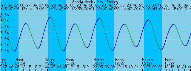
Below is the forecast of tides around Sandy Hook next week. We will be sampling through high tide; the end of flood currents and beginning of ebb currents. When we get strong flows of freshwater into the ocean on the ebb currents, it is relatively easy to line up sampling transects across ocean features in the vicinity of the two Seascapes. Sharp gradients form where the river of estuarine water rushes in to meet the salty, colder ocean water and those gradients are easy to see in ocean color measured with satellites, currents measured with high frequency radar, and even with the naked eye.
Each day we try to slice the dominant feature defined by a sharp gradient in temperature and/or salinity in the vacinity of each seascape in half with sampling transects that are 10 to 20 km long. This is twice as long as the Rossby radius of deformation for our area. One day an oceanographer will tell me what the Rossby Radius is and I'll get it. The rossby scale for the region was calculated in a paper by Yankowski on the Hudson River Plume (I think and will find the citation). As a soft scientist my dim understanding is that the size of the dominant features of circulation, usually eddies, occur at around the Rossby length scale which is determined by the strength of the currents that change with depth (slower in shallower water because of bottom friction), and by Coreolis force which changes with latitude (higher near the poles than the equator) and causes the eddies to spin (Check this explanation with a liscensed professional). Since the fish can't overcome physics, 2xs the length scale of the dominant physical features of the ocean should be the right transect length to sample the fish. We then sample at multiple depths along the transect at 5-7 stations offshore, on and inshore of the dominant ocean feature we find near the seascape. With freshwater rushing out of the estuary on the ebb tides its relatively easy to find the areas of turbulence (surface slicks, areas of with "confused" seas) along the fronts. We also have a YSI probe mounted on our research ship just below the surface. It continuously measures salinity and temperature along the ship track and we can identify the fronts between two water masses by the rapid change in either temperature or salinity in the data from that probe.
No comments:
Post a Comment